


#destinations
10 of Hong Kong’s most scenic hiking trails to explore this winter
![]() BY Kenneth Chan
BY Kenneth Chan
November 18, 2021
As we embrace the dropping temperatures in Hong Kong, there’s no better time than now to explore some of the city’s most scenic hiking trails
With the return of cooler and finer weather, there is nothing like going out and getting some fresh air on a hike amidst Hong Kong’s beautiful landscape. With hundreds of hiking trails to choose from, you will be spoilt for choice, whether your goal is simply to take a break from hectic city life or tackle a strenuous trail up in the mountain. Here we have selected ten hikes with stunning views that are not too far away from the city area.
Violet Hill, The Twins
This is a challenging hike with flights of stairs and dirt paths up and down three peaks, but you will be awarded the magnificent view of the Stanley peninsula dotted with luxury villas and colonial relics. Start near Hong Kong Parkview above Wong Nai Chung Reservoir, the trail leading to Violet Hill allows you to enjoy the view of Tai Tam Country Park and Repulse Bay before climbing up more than 1,000 steps to The Twins. The splendid view of the Stanley peninsula will unfold as you start descending from the second peak of The Twins to the Stanley Gap Road, where you can proceed to the waterfront town to celebrate your hard work at one of the many bars and restaurants.
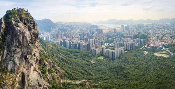
Dragon’s Back
This world-famous mountain ridge in southeastern Hong Kong island needs no introduction as it is frequently hailed by international media as the most scenic hiking trail in the city. You can start at Shek O Road near To Tei Wan Village and follow the trail along the mountain ridge before descending to Big Wave Bay. You can enjoy an uninterrupted ocean view in most parts of the 8.5km trail. Not to miss the sightseeing platform on the top of the peak, where you can have a majestic view of Shek O with all the luxury villas.
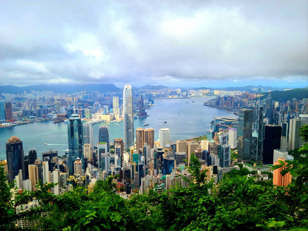
Lion Rock Peak, Amah’s Rock
A symbol of the “Hong Kong Spirit”, Lion Rock is the best place for a panorama view of the Kowloon Peninsula and even Hong Kong Island. There are several routes leading to Lion Rock. A shorter but more challenging one is from Lion Rock Country Park near Tin Ma Court in Wong Tai Sin. Take the steps and dirt path uphill until you reach the Unification Pavilion and follow the sign to the Lion Rock. After spending your time appreciating the view and taking photos, return to the pavilion where you can descend on the other side of the peak to Amah Rock, a rock formation resembling a woman carrying a baby on her back, for the sweeping view of the new towns of Tai Wai and Shatin.
Ng Tung Chai Waterfalls
This challenging 12km round trip hike brings you to four of Hong Kong’s most spectacular waterfalls. Start from the Ng Tung Chai bus stop on Lam Kam Road and follow the uphill trail leading to the Bottom Fall, Middle Fall, Main Fall and Scatter Fall. With a drop of 35 metres, the Main Fall with a large pool is the highest in Hong Kong. The stepped path uphill is rough and steep and narrow in some places. So make sure you have suitable hiking shoes and gear and avoid going there alone and in bad weather.
Reservoir Islands (Thousand Island Lake)
Probably the easiest hike on our list, these reservoir islands in the Tai Lam Chung Reservoir near Tuen Mun have become a hot spot for Instagram photos in recent years. These dozens of small islands were actually hills before the valley was flooded by water to form the reservoir. The 7km family-friendly walk starts and finishes at So Kwan Wat Village, accessible by minibus 43, from San Hui Market near Tuen Mun MTR Station. Walk along the concrete path near the public toilet, and soon you will see a signpost pointing to Reservoir Islands Viewpoint 2.5km away. Follow the uphill path and steps to reach the viewpoint, which is the best location to see the islands.
Lau Shui Heung Reservoir, Hok Tau Reservoir
A mountain ridge separates these two disuse irrigation reservoirs within the Pak Sin Leng Country Park, so it’s convenient to combine the two in one visit. The two reservoirs are served by the same minibus, 52B, near the Fanling East Rail Station. Get off at Pak Sin Leng Country Park roundabout and walk to the Lau Shui Heung Reservoir along the concrete road. Lau Shui Heung Reservoir is known for its mirror surface and a line of trees reflected in the water. After visiting the reservoir, you can follow the Lau Shui Heung Country Trail across the ridge to Hok Tau Reservoir. Once you get there, follow the Hok Tau Reservoir Family Walk, which allows you to view the quiet reservoir from different angles.
Tai Long Wan
Not to be confused with the one on Hong Kong Island, Tai Long Wan, or Big Wave Bay, is a 3km unspoilt bay area on the east coast of Sai Kung Peninsula, comprising of four neighbouring beaches of Sai Wan, Ham Tin Wan, Tai Wan and Tung Wan. From Sai Kung Town, take the N29 village bus to Sai Wan Pavilion and follow the path down to Sai Wan Beach. After visiting the beach, follow the MacLehose Trail to Ham Tin Beach, the most popular among the four beaches where you can enjoy your time at the beach and visit the more secluded beaches of Tai Wan and Tung Wan on the other side of the ridge. From Ham Tin, you could catch a speed boat back to Sai Kung Town, walk back to Sai Wan Pavilion or follow MacLehose Trail to Pak Tam Au for public transport.
Tai Tan, Hoi Ha
This is a beautiful coastal hike from Tai Tan to Hoi Hai along the 6.8km Tai Tan Country Trail northeast of Sai Kung Peninsula. Take bus 94 from Sai Kung Town and get off at Tai Tan before the last stop at Wong Shek Pier. Despite some uphill sections, the trail which winds along the hillside is relatively flat, passing two secrete beaches along the way. As you walk along, you can enjoy the majestic view of the Sharp Peak afar and the beautiful coastlines of Grass Island, Sai Kung West Country Park and Hoi Hai Wan, a marine conservation area. There are restaurants at Ho Hai where you can have a meal before taking minibus number 7 back to Sai Kung Town.
Yuen Tsuen Ancient Trail
Starting from Tsuen Wan, this 12.9km route was used by villagers commuting between Yuen Long and Tsuen Wan in the old days. The trail begins right behind the Adventist Hospital, leading uphill to Ha Fa Shan and onward to Shek Lung Kung, where people come for the stunning view of Tsing Ma Bridge and Ting Kau Bridge. If you have no intention to cover the whole distance all the way to Yuen Long, as most hikers do, you can exit at Tsing Fai Tong and follow the route down to Sham Tseng village, where you can sample the famous roast goose before heading back to the city.
Pineapple Hill, Pak Nai
This is a relatively new but unique route among hikers. Said to be the only natural canyon formation in Hong Kong, the Leung Tin Ao Valley is now better known as Pineapple Hill. Its yellowish crackly surface resembles the skin of a pineapple bun. The trail leading to Pineapple Hill is at the back of Leung King Plaza near the Light Rail Station on the MTR Light Rail. After visiting Pineapple Hill, you may continue along the trail towards Ha Pak Lai beach, one of the best places to see the beautiful sunset in Hong Kong.
Also see: Marriott’s farm-to-table staycation elevates luxury dining with local produce